


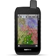
GarminMontana 700, Rugged GPS Handheld, Routable Mapping for Roads and Trails, Glove-Friendly 5" Color Touchscreen
Details
- BrandGarmin
- Model NameMontana 700
- Vehicle Service TypeATV
- Screen Size5 Inches
- Special Feature(function(f) {
- Connectivity TechnologyWi-Fi
Description
🌍 Adventure Awaits: Navigate the Great Outdoors with Confidence!
- RUGGED READY - Built to MIL-STD 810 standards, ensuring durability against the elements.
- GLOVE FRIENDLY DISPLAY - Experience a 5" touchscreen that’s easy to use, even with gloves on.
- LONG LASTING ADVENTURE - Enjoy up to 18 hours of battery life for extended outdoor excursions.
- PRO CONNECTED FEATURES - Access BirdsEye Satellite Imagery and location sharing directly from your device.
- NAVIGATE WITH CONFIDENCE - Equipped with Multi-GNSS support for precise outdoor navigation.
The Garmin Montana 700 is a rugged GPS handheld device designed for outdoor enthusiasts. It features a glove-friendly 5" color touchscreen, MIL-STD 810 rated durability, and supports multiple GNSS systems for accurate navigation. With preloaded TopoActive maps and advanced connectivity options, it’s perfect for hiking, biking, kayaking, and ATV adventures.
Specifications
| Touch Screen Type | Capacitive |
| Display Type | WVGA transflective, dual orientation |
| Human-Interface Input | Touchscreen |
| Are Batteries Included | Yes |
| Connectivity Protocol | Bluetooth, ANT+, Wi-Fi |
| Sport Type | ['Hiking', 'Biking', 'Kayaking', 'ATV'] |
| Battery Average Life | 18 Hours |
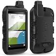
| Mount Type | Wrist Mount, found in image |
| Resolution | 480 x 800 |
| Compatible with Vehicle Type | ATV |
| Screen Size | 5 Inches |
| Additional Features | Routable Topo Maps; Multiple GNSS Networks, ABC Sensors; BirdsEye Satellite Imagery; IPX7 Rated and Shock Resistant |
| Connectivity Technology | Wi-Fi |
| Map Types | North America |
| Item Weight | 14.56 ounces |
| Item Dimensions L x W x H | 8.54"L x 5.9"W x 3.26"H |
Reviews
L**S
Love this GPS.
Great GPS. Much better than the old Garmin Montana 700 I had. Bigger screen and has a better grip. Not the fault of the GPS but OnX maps doesn't make a chip for hand held GPS anymore. 😡. Glad that they make a AA battery adapter backup for this GPS.
R**N
A good GPS
I've been known to go on long hikes and even backpacking by myself. My son has inherited that tendency, so several years ago I bought him a Garmin Montana. It heelps him find his way, and the inReach cpability lets his send messages to let people know he's OK. I had a smaller Garmin I've used for years, and a Spot that I carried for communication and emergencies. After looking at that nice big screen, I decided to make the switch. Yeah, it's a lot bigger than my old Garmin eTrex, but it also lets me communicate, and it gives me a good topo display. I've got the 24K-series chip with topos for Wa, Or, Ca & Hi. Works great: I live in Wa and my son lives in Ca. We usually meet somewhere in that region for backpacking trips, and most of my solo trips are in Wa or Or. I still carry a compass and a paper map, but it's great to be able to see the topography on the screen. I'm a little concerned about battery life. So far, it's worked pretty well on 2-3 day trips, but for a longer trips, I'd make sure to take a power bank to keep it charged. On a recent trip on the south side of the Wallowa Mtns, we also used it to find a route for the car. It sent us down a logging trail that was barely passable. Even a 4WD with good ground clearance would have had problems. In the future, I think I'll turn off the 24K maps when I'm driving.
E**D
Its big
Big screen, a bit hard to use, could really use better graphics, given todays google earth quality on a computer. Needs higher resolution. Hasn't changed much after many older models other then getting a bigger screen. Pricey as well.
M**R
Garmin cannot code their way out of a paper bag
I am on the verge of returning this. Garmin continues to have stellar hardware, but some of the worst software that money can buy. I thought I would give the Montana 700i a chance, but so far it's just as terrible as my Garmin 1030i bike computer that's navigation feature returns "Route Calculation Error" for literally every time I try and navigate with it, or my 920xt that could not track my freestyle laps in the pool correctly even with a warranty replacement. The Montana is missing some very basic features. It comes out of the box with only a tiny amount of memory available to save additional maps on, but its software can only handle a 32gb SD card. Already when downloading maps I've received four different errors not related to being out of room. The fifth time it froze up during the download. I really hate to imagine that people use Garmin devices in airplanes. Perhaps they are a bunch of private planes up there right now flying in circles with "Route Calculation Error" on their screen.Even their website doesn't work right. Note the screenshot. This was my first time ever logging into their Explore service. The fact it has a status message in the upper right is hilarious. I can imagine some upper manager saying "Let's put the user in charge of managing our severe lack of talent in software development". Of course even that indicator is broken, since I can't get past that error screen.Update: I’ve been using (paying for) their InReach satellite service. Others can receive my messages but I’ve yet to see replies they sent me, even when I was outside under a clear sky. Next to worthless.More: I downloaded maps ahead of time with the Maps Manager for my destination. When I got there, they weren’t visible at all. I switched between every layer and nothing.Fix your software, Garmin.Update: their updates make the product worse. The latest update I just received causes the button used to start tracking to no longer work. If you press it, it just sits there. Garmin, how about some basic regression testing?
B**N
A clumsy heavy GPS that you may desperately need
I bought the Montana 700i almost a year ago. My purpose was to have high quality maps loaded which do not depend on cell data access, given that sometimes I might be 80 miles from a place where I could make a phone call, much less get data. Given that I am sometimes very remote, I wanted the InReach technology so I could call for help, and keep in touch with my family. I use the 700i when driving (in conjunction with a Garmin Nuvi, which works better for that) and also for daily walks and hiking. This GPS can be used as a driving GPS (with voice) just like Garmin's driving GPSs if one purchases the associated suction cup mount (with integrated AMPS plate) but the routing calculations are slow, the screen is a bit small, and major intersection signs are not show as the dedicated driving GPSs do.Unfortunately, the Montana started having issues with going black, locking up, or needing to be restarted. At first I though that it was something I was doing (battery, cable, charger, etc), but the problem kept getting worse. So two weeks before the 1 year warranty expired, I requested a replacement unit and so now I have a new one.Important things to know about the 700i is that it is heavy, and the maps require downloading huge files (e.g. 5GB for one map) which can take quite a long time unless your Internet connection is very fast. The downloads seem to time out (especially on the popular maps) so it is necessary to restart them manually and nurse them along until they are done. For me it took over a day to download all of the maps for the GPS. The Garmin Express app used to update the maps has always been poorly implemented and it lies about what it is doing and what has gone wrong.I would complain about Garmin's support, but my recent support experiences have been very good as if they totally revamped their support department, whereas they were very poor a year ago.
Common Questions
Trustpilot
1 month ago
1 month ago
Get the App
